![](/images/other/stat-length.png)
![Excursión Senderismo La Roche-sur-Foron - GLIERES / BORNES: LE CHENET - SUR COU - COL DU FREU - ROCHE PARNAL - COL DU CABLE - BALME - Photo](https://media.geolcdn.com/t/1900/400/76d2b98a-db75-45e7-be8c-e548d2cdd9d7.jpg&format=pjpeg&maxdim=2)
GLIERES / BORNES: LE CHENET - SUR COU - COL DU FREU - ROCHE PARNAL - COL DU CABLE - BALME
djeepee74
Usuario
![Longitud](/images/other/stat-length.png)
![Altitud máxima](https://static1.geolcdn.com/siteimages/upload/files/1508320355ic_sort_altitude_max_24dp.png)
![Desnivel positivo](https://static1.geolcdn.com/siteimages/upload/files/1508320355ic_sort_den_pos_24dp.png)
![Km-Effort](/images/other/stat-length.png)
![Altitud mínima](https://static1.geolcdn.com/siteimages/upload/files/1508320355ic_sort_altitude_min_24dp.png)
![Desnivel negativo](https://static1.geolcdn.com/siteimages/upload/files/1508320355ic_sort_den_neg_24dp.png)
![Boucle](https://static1.geolcdn.com/siteimages/upload/files/16400158638029165_repeat_loop_refresh_sync_direction_icon.png)
![Senderismo](https://static1.geolcdn.com/sitytour/trail-icons/101.png)
5h15
Dificultad : Difícil
![Escanee este código QR para abrir la excursión en la aplicación SityTrail](https://capi.geolives.com/qq0zvz2zws4bq2lad0pu/sitytour/trails/2807686/qr.png?size=200)
Aplicación GPS de excursión GRATIS
A propósito
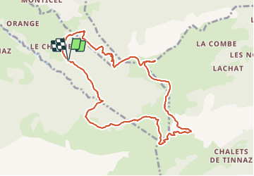
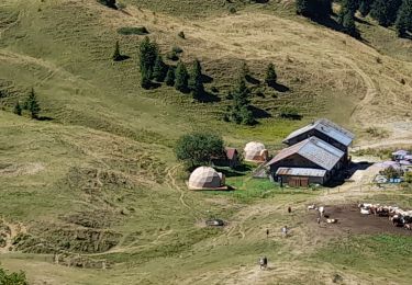
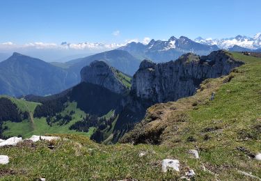
Ruta Senderismo de 10,4 km a descubrir en Auvergne-Rhône-Alpes, Alta Saboya, La Roche-sur-Foron. Esta ruta ha sido propuesta por djeepee74.
Descripción
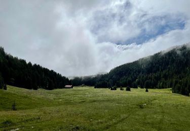
BOUCLE... live du 20210530
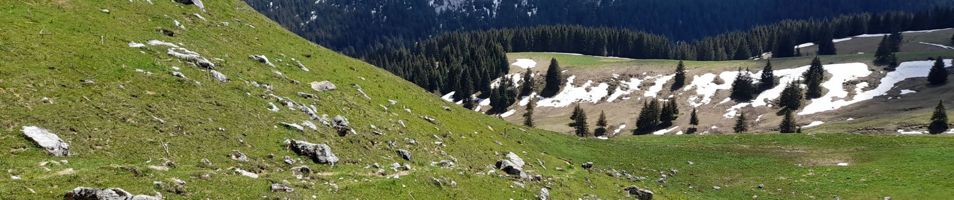
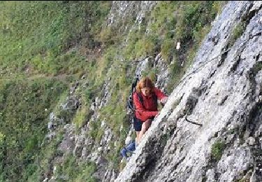
Encore quelques névés dans la montée du col du Freu.
Par contre, que des névés depuis le col du Freu jusqu'au niveau de l'arête sommitale menant à la Roche Parnal.
Enfin, un autre névé au tout début de la descente au col du câble.
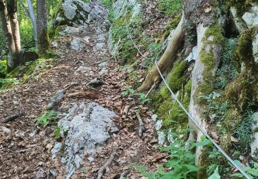
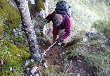
Pour info: Dans le sens de la descente, le passage du câble peut "impressionner".
Localización
Comentarios
Excursiones cerca
![Excursión Senderismo La Roche-sur-Foron - 74 roche parnal 05.08.2022 - Photo](https://media.geolcdn.com/t/375/260/ba549e5b-64c8-4769-981b-da36531c207b.jpg&format=jpg&maxdim=2)
![Senderismo Senderismo](https://static1.geolcdn.com/sitytour/trail-icons/101.png)
Senderismo
![](/images/other/stat-length.png)
![](https://static1.geolcdn.com/siteimages/upload/files/16400158638029165_repeat_loop_refresh_sync_direction_icon.png)
![Excursión Senderismo Fillière - 12-06-2022 Col de l'Enclave - Photo](https://media.geolcdn.com/t/375/260/d6de4e1d-df10-43ee-a034-704376f533a0.jpg&format=jpg&maxdim=2)
![Senderismo Senderismo](https://static1.geolcdn.com/sitytour/trail-icons/101.png)
Senderismo
![](/images/other/stat-length.png)
![](https://static1.geolcdn.com/siteimages/upload/files/16400158638029165_repeat_loop_refresh_sync_direction_icon.png)
![Excursión Senderismo La Roche-sur-Foron - sur cou par a grotte face ouest - Photo](https://media.geolcdn.com/t/375/260/eb887393-e50d-4ca6-9d35-a9f45379ad0a.jpg&format=jpg&maxdim=2)
![Senderismo Senderismo](https://static1.geolcdn.com/sitytour/trail-icons/101.png)
Senderismo
![](/images/other/stat-length.png)
![](https://static1.geolcdn.com/siteimages/upload/files/16400158638029165_repeat_loop_refresh_sync_direction_icon.png)
![Excursión Senderismo La Roche-sur-Foron - Tour de Sur Cou - Photo](https://media.geolcdn.com/t/375/260/ext.jpg?maxdim=2&url=https%3A%2F%2Fstatic1.geolcdn.com%2Fsiteimages%2Fupload%2Ffiles%2F1553511878bg_sport_marche.png)
![Senderismo Senderismo](https://static1.geolcdn.com/sitytour/trail-icons/101.png)
Senderismo
![](/images/other/stat-length.png)
![](https://static1.geolcdn.com/siteimages/upload/files/16400158638029165_repeat_loop_refresh_sync_direction_icon.png)
![Excursión Senderismo La Roche-sur-Foron - sur cou - Photo](https://media.geolcdn.com/t/375/260/ext.jpg?maxdim=2&url=https%3A%2F%2Fstatic1.geolcdn.com%2Fsiteimages%2Fupload%2Ffiles%2F1553511878bg_sport_marche.png)
![Senderismo Senderismo](https://static1.geolcdn.com/sitytour/trail-icons/101.png)
Senderismo
![](/images/other/stat-length.png)
![](https://static1.geolcdn.com/siteimages/upload/files/16400158638029165_repeat_loop_refresh_sync_direction_icon.png)
![Excursión Senderismo La Roche-sur-Foron - GLIERES / BORNES: COL DU COU - CHALET DE BALME - Photo](https://media.geolcdn.com/t/375/260/2269b6ac-8de6-4ba7-afa5-8ad4f3fdc650.jpg&format=jpg&maxdim=2)
![Senderismo Senderismo](https://static1.geolcdn.com/sitytour/trail-icons/101.png)
Senderismo
![](/images/other/stat-length.png)
![](https://static1.geolcdn.com/siteimages/upload/files/16400158638029165_repeat_loop_refresh_sync_direction_icon.png)
![Excursión Senderismo La Roche-sur-Foron - 2021-09-22_09h20m43_activity_7510877141 - Photo](https://media.geolcdn.com/t/375/260/e824a6be-a989-475f-b580-3fc1c5ae3b2a.jpg&format=jpg&maxdim=2)
![Senderismo Senderismo](https://static1.geolcdn.com/sitytour/trail-icons/101.png)
Senderismo
![](/images/other/stat-length.png)
![](https://static1.geolcdn.com/siteimages/upload/files/16400158638029165_repeat_loop_refresh_sync_direction_icon.png)
![Excursión Curso de orientación Glières-Val-de-Borne - exp_16 juil. 2021 à 08-45-33 - Photo](https://media.geolcdn.com/t/375/260/a0b647e0-bb93-48e0-b524-ce1b6bdde353.jpeg&format=jpg&maxdim=2)
![Curso de orientación Curso de orientación](https://static1.geolcdn.com/sitytour/trail-icons/906.png)
Curso de orientación
![](/images/other/stat-length.png)
![](https://static1.geolcdn.com/siteimages/upload/files/16400158638029165_repeat_loop_refresh_sync_direction_icon.png)
![Excursión Senderismo Fillière - Sous-Dines Par Le Monthieu 12-06-2021 - Photo](https://media.geolcdn.com/t/375/260/0bc5ea95-6846-42e9-95b1-90fe58a4bc7e.jpg&format=jpg&maxdim=2)
![Senderismo Senderismo](https://static1.geolcdn.com/sitytour/trail-icons/101.png)
Senderismo
![](/images/other/stat-length.png)
![](https://static1.geolcdn.com/siteimages/upload/files/16400158638029165_repeat_loop_refresh_sync_direction_icon.png)